Sponsored
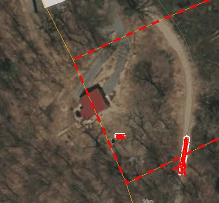
So I was looking at my property on the County GIS page.....
TJC
Well-Known Member
- First Name
- Tony
- Joined
- Aug 28, 2020
- Threads
- 45
- Messages
- 3,932
- Reaction score
- 9,867
- Location
- North Carolina
- Vehicle(s)
- 93 Miata, 05 Ranger 4x4, 20 Ranger 4x4, 23 CX-5
Hopefully he owns both lotsI guess I shouldn't complain, this guy's house is half on an adjacent 200+ acre property. Sure hope that's a perspective error.

subquark
Well-Known Member
- First Name
- David
- Joined
- Jan 28, 2022
- Threads
- 11
- Messages
- 4,544
- Reaction score
- 23,071
- Location
- Portsmouth, NH
- Website
- subQuark.com
- Vehicle(s)
- Soupie! Race Red '22 XL 101A Scab 4X2 w/steelies
- Occupation
- game publisher
I have a similar issue in that the GIS maps are not exact. They are close but not close enough for me to tell if a line of bushes is on my side or my neighbors. Unfortunately, only a survey can be that precise. I have gone out numerous times with a 100 foot measure and measured from the various ways I can render the GIS map (with Google, diff aerial shots, and a plat map) but they all come out with uncertainty of about 2 feet - right where I need to know.
subquark
Well-Known Member
- First Name
- David
- Joined
- Jan 28, 2022
- Threads
- 11
- Messages
- 4,544
- Reaction score
- 23,071
- Location
- Portsmouth, NH
- Website
- subQuark.com
- Vehicle(s)
- Soupie! Race Red '22 XL 101A Scab 4X2 w/steelies
- Occupation
- game publisher
Communal living at its best!I guess I shouldn't complain, this guy's house is half on an adjacent 200+ acre property. Sure hope that's a perspective error.
TJC
Well-Known Member
- First Name
- Tony
- Joined
- Aug 28, 2020
- Threads
- 45
- Messages
- 3,932
- Reaction score
- 9,867
- Location
- North Carolina
- Vehicle(s)
- 93 Miata, 05 Ranger 4x4, 20 Ranger 4x4, 23 CX-5
Then he either has a best friend who owns that lot or he is $#*& out of luck!Not according to the GIS data.

FerdRanger
Well-Known Member
- First Name
- Ferdinand the Great
- Joined
- Sep 28, 2021
- Threads
- 6
- Messages
- 319
- Reaction score
- 1,210
- Location
- Central NY
- Vehicle(s)
- 2020 Ranger Lariat Sport 4x4
- Occupation
- no thanks
I have a similar issue in that the GIS maps are not exact. They are close but not close enough for me to tell if a line of bushes is on my side or my neighbors. Unfortunately, only a survey can be that precise. I have gone out numerous times with a 100 foot measure and measured from the various ways I can render the GIS map (with Google, diff aerial shots, and a plat map) but they all come out with uncertainty of about 2 feet - right where I need to know.
quickest way to find out is cut ’em down
TJC
Well-Known Member
- First Name
- Tony
- Joined
- Aug 28, 2020
- Threads
- 45
- Messages
- 3,932
- Reaction score
- 9,867
- Location
- North Carolina
- Vehicle(s)
- 93 Miata, 05 Ranger 4x4, 20 Ranger 4x4, 23 CX-5
That's a bridge that once crossed can't be uncrossed. But you have a 50% chance of being OK... maybe higher, the owner may wish the bushes to be cut down! He may thank you!quickest way to find out is cut ’em down

UncleWillie
Well-Known Member
TLDR: I wouldn't worry about it. GIS, tax maps, tax databases can be wonky.
I do a lot of GIS work (albeit not as much as I used to) and I have to stay on certain properties when I am out in the field doing work. There are several things that could be happening here. Post #76 is a projection issue. A lot of satellite or aerial imagery is projected in one coordinate system (sometimes on a global or national scale) whereas the property boundaries are recorded and projected in a different coordinate system (usually on a state level or smaller). When the images are overlaid, they just don't line up.
As far as your acreage issues with you and your neighbor, I just think this is the result of property lines and an old database. I have a similar issue with my county's GIS portal. I have a hair over 2 acres. When you click on my parcel, it shows up over 34 acres. My tax payment is based on the 2 acres, but the original GIS database is still tied to a property that the previous landowner had with an "outparcel" property about 0.25-mile down the road. So when you click on my 2 acres, only my 2 acres is highlighted, but still references a 32-acre parcel just down the road.
Similarly, my in-laws have a property in SC that has two tiny slivers on the opposite side of the road (the result of a road realignment). They own these little slivers, but they do not get highlighted when using the County's GIS site. So if you measure the "main property" it tells you the entire acreage owned, but does not show the two slivers. If you subtract those two slivers, they have "lost" about a 0.5 acre.
Motorpsychology
Well-Known Member
- First Name
- Chris
- Joined
- Nov 13, 2019
- Threads
- 21
- Messages
- 3,291
- Reaction score
- 11,490
- Location
- Prescott, WI
- Vehicle(s)
- 2021 Ranger STX SuperCab 4X4 Carbonized grey; 2025 Mazda CX-90 Platinum Quartz
- Occupation
- Vagabond
When we were house hunting for our second house, we looked at an older home with an in-ground swimming pool on one side of the lot. GIS showed that the fence and 18 inches of the pool area were in the neighbor's lot, the pool itself was totally within the prospective lot, with virtually zero setback. The neighbor was apparently OK with this, though we never checked with them, thinking that while they were ok with it, a future buyer might not be. That was 30 years ago and glory be, the pool and fence surround are gone.
OP
OP
got3fords
Well-Known Member
- Thread starter
- #56
My Mom's house, which we are getting ready to sell, has her driveway half way on the adjacent lot. We grew up there and took care of the lot, even had a garden on it. Now we are dealing with how her lot and adjacent lots are very weirdly laid out.When we were house hunting for our second house, we looked at an older home with an in-ground swimming pool on one side of the lot. GIS showed that the fence and 18 inches of the pool area were in the neighbor's lot, the pool itself was totally within the prospective lot, with virtually zero setback. The neighbor was apparently OK with this, though we never checked with them, thinking that while they were ok with it, a future buyer might not be. That was 30 years ago and glory be, the pool and fence surround are gone.
Fordup
Well-Known Member
- First Name
- Ed
- Joined
- Jun 3, 2022
- Threads
- 17
- Messages
- 1,934
- Reaction score
- 9,548
- Location
- NY
- Website
- youtube.com
- Vehicle(s)
- 2022 Black Lariat Crew , 1966 Chevrolet Biscayne
- Occupation
- Retired YouTube Creator
Years ago my wife and I went to contract on a house with a couple acres. Survey showed the neighbor had built a porch on the property and their house had zero setback before the porch plus another half acre was missing when done for the closing. Needless to say, we walked and got the deposit back. It seems older maps were never really surveyed when drawn, and pins were moved over the years. Surveyor had to start at the last real documented survey pins a half mile up the road because nothing was right in the area.
Last edited:
OP
OP
got3fords
Well-Known Member
- Thread starter
- #58
At least three actual stakes are locatable on my property. Which pretty closely align with the tax maps. I think with a little effort the few remaining markers could be located keeping in mind my property lines have many different angles. My farmer neighbor had all his property surveyed a few years ago, and what they found was right in line with what I later researched. Come to find out, I own both sides of about 75 yards of a small creek. Good to know because I spent a lot of time clearing it and making it pretty and accessible. It was grown over and had lots of poison ivy etc.
Sponsored